

Who Controls the Satellites Orbiting Earth? Countries, Companies and Global Rules Explained
August , 2026 : Thousands of artificial satellites now travel above Earth, quietly supporting services used by governments, businesses and ordinary households every day. They help people navigate roads, predict storms, communicate across oceans, monitor crops, manage financial networks, observe military activity and connect remote communities to the internet.
The rapid expansion of satellite constellations has also created a more complicated question: who controls the growing number of objects above Earth, and which international organization is responsible for governing them? There is no single global authority controlling every satellite. Instead, responsibility is divided among national governments, the United Nations, international telecommunications regulators, satellite operators and space-tracking organizations.
How many active satellites are orbiting Earth?
The number changes frequently as new satellites are launched, old spacecraft stop operating and some objects re-enter Earth’s atmosphere.
Jonathan McDowell’s independent satellite statistics recorded 16,234 active satellites in orbit as of 8 July 2026. The same dataset listed more than 3,100 other dead satellite payloads, over 2,000 rocket stages and more than 11,000 catalogued debris objects.
CelesTrak’s Satellite Catalog reported a slightly higher total of approximately 16,700 active satellites at the beginning of August 2026, depending on whether tracked, restricted and temporarily lost objects were included.
The difference does not necessarily mean one database is incorrect. Organizations use different methods to determine whether a satellite is active, partially operational, in reserve, maneuverable or no longer functioning. A responsible description is therefore: More than 16,000 active satellites were orbiting Earth by mid-2026, although the exact total changes regularly and depends on how each database classifies operational spacecraft.
A satellite is not the same as every tracked object
The phrase “satellites in space” is sometimes used incorrectly to describe every human-made object orbiting Earth.
Orbital catalogues may include:
|
Type of object |
Meaning |
| Active satellite | A spacecraft still carrying out a mission or providing a service |
| Inactive satellite | A spacecraft that is no longer operating |
| Rocket body | A launch-vehicle stage remaining in orbit |
| Mission-related object | Covers, adapters or other equipment released during deployment |
| Fragmentation debris | Pieces created by an explosion, collision or break-up |
| Anti-satellite-test debris | Fragments created when a spacecraft is deliberately destroyed |
| Unidentified object | A tracked object whose origin or purpose has not been fully confirmed |
The European Space Agency reported in 2025 that around 40,000 objects were being tracked by space-surveillance networks at that time, including approximately 11,000 active payloads. ESA has repeatedly warned that debris continues to accumulate faster than it is being removed from important orbital regions.
The number of active satellites has since continued to rise rapidly, largely because of the deployment of large communications constellations.
Which country has the most satellites?
The United States has by far the largest active satellite fleet.
However, the size of the American fleet is strongly influenced by SpaceX and its Starlink broadband constellation. Jonathan McDowell recorded 10,736 active Starlink satellites in orbit on 8 July 2026 – around two-thirds of all active satellites in his dataset.
China has the second-largest major national satellite presence, with extensive systems supporting communications, Earth observation, navigation, weather forecasting, scientific research and national security.
The United Kingdom also appears high in many satellite rankings because of satellites associated with the OneWeb constellation and UK-registered operators. Russia remains a major space power with communications, navigation, military, weather and scientific spacecraft.
Other important satellite-operating countries and regions include:
- Japan;
- India;
- France;
- Germany;
- Canada;
- Italy;
- South Korea;
- Luxembourg;
- Israel;
- the United Arab Emirates;
- the wider European Union.
Exact rankings after the United States and China can vary according to how nationality is assigned.
Why satellite nationality is complicated
A satellite may be connected to several countries simultaneously.
For example:
- its operator may be headquartered in one country;
- the spacecraft may be manufactured in another;
- it may be launched from a third;
- its financing may come from several countries;
- it may be formally registered by a different launching state;
- its mission-control centre may operate from another territory.
The country associated with a satellite in a commercial database is therefore not always identical to the country legally responsible for registering it with the United Nations.
When using satellite rankings, readers should check whether the figures refer to the satellite’s operator, owner, registering state, launching state or manufacturer.
Where can readers find a list of satellites?
There is no single database that perfectly answers every satellite question. Different databases are useful for different purposes.
- CelesTrak
CelesTrak provides current orbital data, satellite names, catalogue numbers and groups of spacecraft organized by mission type.
Its public data includes active satellites, Starlink spacecraft, navigation satellites, weather satellites, space stations, amateur-radio spacecraft and many other categories.
CelesTrak is particularly useful for:
- locating a named satellite;
- viewing orbital height and inclination;
- downloading orbital element data;
- identifying groups of active spacecraft;
- comparing constellations.
Its orbital information is updated frequently.
- Space-Track.org
Space-Track.org provides data from the United States space-surveillance system and is an important source for tracking artificial objects around Earth. The service provides satellite-catalogue and positional information, collision-screening resources and information about close approaches between orbiting objects. Some services require registration.
- ESA Space Environment Statistics
The European Space Agency provides statistics on launches, operating satellites, debris, collision risk and the long-term condition of Earth’s orbital environment. ESA’s resource is particularly useful for readers interested in space debris and sustainability rather than individual satellite positions.
- United Nations Register of Objects Launched into Outer Space
The United Nations Office for Outer Space Affairs maintains the UN Register and an Online Index of Objects Launched into Outer Space. The information is supplied by states and international organizations under the Registration Convention and related UN resolutions. The UN system is important for legal registration and international transparency. It is not designed primarily as a real-time tracker of whether every spacecraft is currently operating.
- Jonathan McDowell’s General Catalog of Artificial Space Objects
Astronomer Jonathan McDowell maintains a detailed independent catalogue and statistical resource covering active satellites, dead payloads, constellations, launch history and debris. The database is especially useful for understanding why totals differ and how satellites are classified. Its methodology also acknowledges that the operating status of some spacecraft can be uncertain.
- Can satellites be watched live?
Several websites display satellites moving around a digital model of Earth. However, most so-called live satellite trackers are not continuously watching each satellite through a camera or radar. Instead, they calculate the likely position of a spacecraft from regularly updated orbital data.
Useful public trackers include:
| Website | Best use |
| CelesTrak | Technical orbital data and satellite groups |
| N2YO | Finding individual satellites and visible passes |
| Heavens-Above | Checking when bright satellites pass over a location |
| SatelliteMap.space | Visualizing large numbers of objects around Earth |
| LeoLabs | Understanding objects and congestion in low Earth orbit |
| Space-Track.org | Authoritative catalogue and tracking data for registered users |
Users should remember that displayed positions are estimates based on orbital information. Accuracy depends on how recent the underlying data is and whether the spacecraft has maneuvered.
Which companies are most influential in satellites?
Influence should not be measured only by the number of spacecraft a company owns.
A company may be influential because it controls launch capacity, satellite manufacturing, high-resolution imagery, global communications, military contracts or an important orbital network.
- SpaceX
SpaceX has become the most visible commercial satellite operator through Starlink.
Its importance comes from the combination of:
- a very large low Earth orbit communications constellation;
- its own reusable launch system;
- broadband services;
- government and military communications;
- direct-to-mobile development;
- the ability to deploy new satellites frequently.
The combination of launch capability and satellite ownership gives SpaceX a level of vertical integration that most operators do not possess.
- Eutelsat Group and OneWeb
Eutelsat operates traditional geostationary communications spacecraft and the OneWeb low Earth orbit constellation. This gives it a presence across different orbital systems and allows it to serve governments, airlines, maritime operators, telecommunications companies and remote communities.
- SES
SES is a major international communications operator with spacecraft in geostationary and medium Earth orbit. Its services support broadcasting, aviation, maritime operations, telecommunications, businesses and governments.
- Amazon Leo
Amazon’s low Earth orbit satellite programme, previously known as Project Kuiper, is designed to provide broadband connectivity. Its potential influence extends beyond satellites because Amazon also controls major cloud-computing, logistics and consumer-service infrastructure.
- Planet Labs
Planet operates a large Earth-observation fleet capable of repeatedly imaging extensive areas of the planet. Its data is used for agriculture, mapping, forestry, environmental monitoring, disaster assessment and security analysis.
- Maxar Intelligence
Maxar is a major provider of high-resolution satellite imagery and geospatial intelligence. Its products are widely used by governments, news organizations, defense customers and commercial industries.
- ICEYE
ICEYE specializes in synthetic-aperture radar satellites. Radar imaging can work at night and through cloud cover, making it valuable for monitoring floods, maritime activity, infrastructure, disasters and military developments.
- Iridium
Iridium operates a global mobile satellite-communications network. Its services are used in aviation, maritime transport, emergency response, defense and remote locations where conventional mobile networks are unavailable.
Other influential operators and manufacturers
Other important names include:
- Intelsat;
- Viasat;
- Telesat;
- Globalstar;
- AST SpaceMobile;
- BlackSky;
- Airbus Defence and Space;
- Thales Alenia Space;
- Lockheed Martin;
- Northrop Grumman;
- Boeing;
- Rocket Lab.
China also has a large and expanding state and commercial satellite sector. Some of its most strategically important systems are operated through government institutions and state-owned enterprises rather than Western-style publicly listed satellite companies.
Is there one global satellite-governance organization?
No single world authority licenses, tracks and controls every satellite. Instead, governance is divided between several bodies.
- United Nations Committee on the Peaceful Uses of Outer Space
The United Nations Committee on the Peaceful Uses of Outer Space, commonly known as COPUOS, is the principal UN forum for international discussions about the peaceful use of space.
Its work includes:
-international space law;
-registration;
-space sustainability;
-scientific cooperation;
-capacity-building;
-emerging questions about commercial and governmental space activity.
- United Nations Office for Outer Space Affairs
UNOOSA supports the work of COPUOS, maintains space-law resources and receives registration information from states and international organizations.
The United Nations registration framework helps identify space objects and their responsible registering states.
- International Telecommunication Union
The ITU has a different but highly important role.
It coordinates the use of radio-frequency spectrum and satellite-orbit resources. Satellite networks must communicate without creating unacceptable interference for other systems.
The ITU Radio Regulations form a binding international treaty governing how the radio-frequency spectrum is shared, including its use by space services.
The ITU helps:
- coordinate satellite frequencies;
- record satellite and Earth-station assignments;
- manage potential interference;
- coordinate new networks with existing systems;
- develop global technical standards.
The ITU does not fly satellites, approve every launch or operate a worldwide orbital traffic-control centre.
- National governments
Private satellite companies are generally licensed and supervised by national authorities.
A company may require approval for:
- satellite communications;
- launch operations;
- radio frequencies;
- Earth imaging;
- export-controlled technology;
- debris-mitigation plans;
- atmospheric re-entry;
- national-security considerations.
Under international space law, states remain responsible for national activities in outer space, including activities conducted by private companies.
- Global Satellite Operators Association
The Global Satellite Operators Association, or GSOA, represents operators, manufacturers, launch providers and other companies across the satellite industry. It works on matters including spectrum, connectivity, non-terrestrial networks and space sustainability. However, it is an industry association rather than an international regulator.
What international laws apply to satellites?
Five principal United Nations treaties form the traditional foundation of international space law:
- Outer Space Treaty of 1967
- Rescue Agreement of 1968
- Liability Convention of 1972
- Registration Convention of 1975
- Moon Agreement of 1979
The treaties address issues including freedom of exploration, non-appropriation of outer space, responsibility for national space activities, registration of space objects, liability and the peaceful use of space. The Outer Space Treaty also prohibits placing nuclear weapons or other weapons of mass destruction in Earth orbit.
However, it does not prohibit every military use of satellites. Communications, navigation, reconnaissance, missile-warning and weather satellites can all support military operations.
Why is space debris becoming a greater concern?
A non-functioning satellite does not automatically disappear. At lower altitudes, atmospheric drag may eventually pull it back towards Earth. At higher altitudes, it can remain in orbit for many years, decades or longer. Collisions are particularly dangerous because one event can produce thousands of fragments. Even a small fragment can cause significant damage because orbital objects travel at extremely high relative speeds.
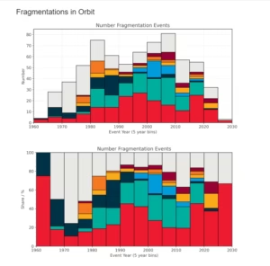
Operators increasingly receive conjunction alerts when two objects are predicted to pass close to each other. Manoeuvrable satellites may be moved, but decisions can be complicated when orbital information is uncertain or when two operators plan avoidance manoeuvres simultaneously. The world still lacks one universal space-traffic-management authority comparable to international air-traffic control.
Does having many satellites make a country more powerful?
Satellite numbers matter, but numbers alone do not tell the whole story.
A country’s real space capability also depends on whether it possesses:
- independent launch vehicles;
- advanced satellite-manufacturing facilities;
- mission-control centres;
- ground stations;
- protected communications;
- navigation systems;
- high-resolution sensors;
- military space capabilities;
- data-processing and artificial-intelligence expertise;
- the ability to replace damaged or failed spacecraft quickly.
A country operating 20 sophisticated reconnaissance, navigation and communications satellites may have greater strategic independence than another country associated with hundreds of small commercial spacecraft.
The most powerful space actors control not only satellites but also the complete system surrounding them.
Frequently Asked Questions : Key Questions About Satellite Ownership and Global Governance
Can anyone launch a satellite?
No. Satellite operations normally require national authorization, radio-frequency coordination, launch arrangements and compliance with safety and registration requirements.
Who owns outer space above a country?
Countries control their national airspace, but outer space is not subject to national ownership in the same manner. The Outer Space Treaty establishes the principle that outer space is not available for national appropriation.
Can a country stop a satellite from flying over it?
Satellites routinely orbit over many countries. International space law does not treat orbital overflight in the same way as an aircraft entering national airspace. However, governments may regulate the use, sale or distribution of sensitive satellite data.
Can satellites collide?
Yes. Operators and space-surveillance organizations regularly assess close approaches. Some spacecraft can manoeuvre to reduce risk, while others cannot.
Who pays if a satellite causes damage?
The Liability Convention creates rules governing international liability for damage caused by space objects. The legal outcome depends on where the damage occurs and the circumstances involved.
Can satellites carry weapons?
The Outer Space Treaty prohibits nuclear weapons and other weapons of mass destruction in orbit. The wider question of conventional weapons and hostile actions in space remains more complicated.
Are all military satellites secret?
No. Many military satellites are publicly acknowledged, although their precise instruments, operating methods and capabilities may remain classified.
Why do satellite totals differ between websites?
Databases use different definitions of active, inactive, operational, reserve and lost spacecraft. They may also update at different times or assign nationality differently.
Are live satellite maps completely accurate?
They are usually calculated from orbital data rather than continuous direct observation. A map may become less accurate when its data is old or when a satellite has recently maneuvered.
Will the number of satellites continue increasing?
The number is likely to grow as companies and governments deploy broadband, Earth-observation, communications, navigation and direct-to-mobile systems. This expansion will increase pressure for stronger debris controls, reliable registration and international coordination.
Satellites are no longer specialized equipment used only by a small group of space agencies.
They have become essential infrastructure supporting economies, security systems, communications and public services. At the same time, a large share of the active satellite population is now controlled by a small number of countries and companies.
International governance exists, but it is divided between legal registration, radio-frequency coordination, national licensing, debris mitigation and voluntary operational cooperation.
As the orbital population continues to expand, the central question will no longer be simply how many satellites are above Earth. It will be whether international rules and tracking systems can develop quickly enough to keep the space environment safe, accessible and sustainable.
Editorial Note: This article is intended for informational and educational purposes only. It provides analytical insights based on publicly available information and does not constitute financial, legal, or political advice. Readers are encouraged to consult official sources and expert advisors for verified guidance.
Information for Readers
This article is intended for general educational and informational purposes only. It does not promote any country, government, company, political position or strategic viewpoint. The content has been prepared using publicly available information from official organizations, space agencies and satellite databases.
Satellite numbers, classifications, ownership details and operational information can change frequently. Readers are encouraged to review the linked official sources and databases for the latest information and independent verification. Any reference to a country, company or organization is included for factual context and should not be interpreted as endorsement, criticism or political influence.
Artemis II Crew Poised to Break All-Time Deep Space Distance Record During Historic Lunar Flyby
NASA Prepares for Historic Multi-Mission Launch to Study Solar Forces
How High Do Satellites Fly? Aircraft, Rockets and Satellite Orbits Compared