

How High Do Satellites Fly? Aircraft, Rockets and Satellite Orbits Compared
July | August 2026 : An aeroplane travelling across the sky can appear extremely high from the ground. A helicopter hovering above a city may also seem far away.
However, both operate very close to Earth when compared with satellites.
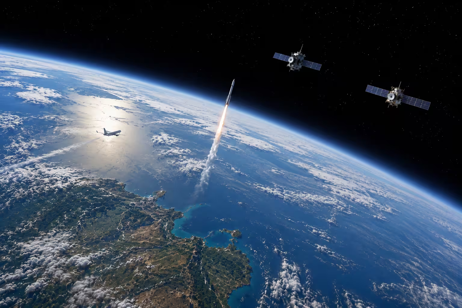
A commercial passenger aircraft commonly cruises at approximately 9 to 12 kilometers above sea level. The International Space Station travels around 400 kilometers above Earth, navigation satellites operate at roughly 20,000 to 23,000 kilometers, and geostationary communications satellites are positioned nearly 36,000 kilometers above the equator.
Understanding these differences helps explain why rockets are needed, why satellites use different orbits and why no single satellite altitude is suitable for every purpose.
How high do helicopters, aeroplanes, rockets and satellites travel?
The figures below are approximate. Actual heights vary according to the aircraft, spacecraft, route, weather, mission and operating rules.
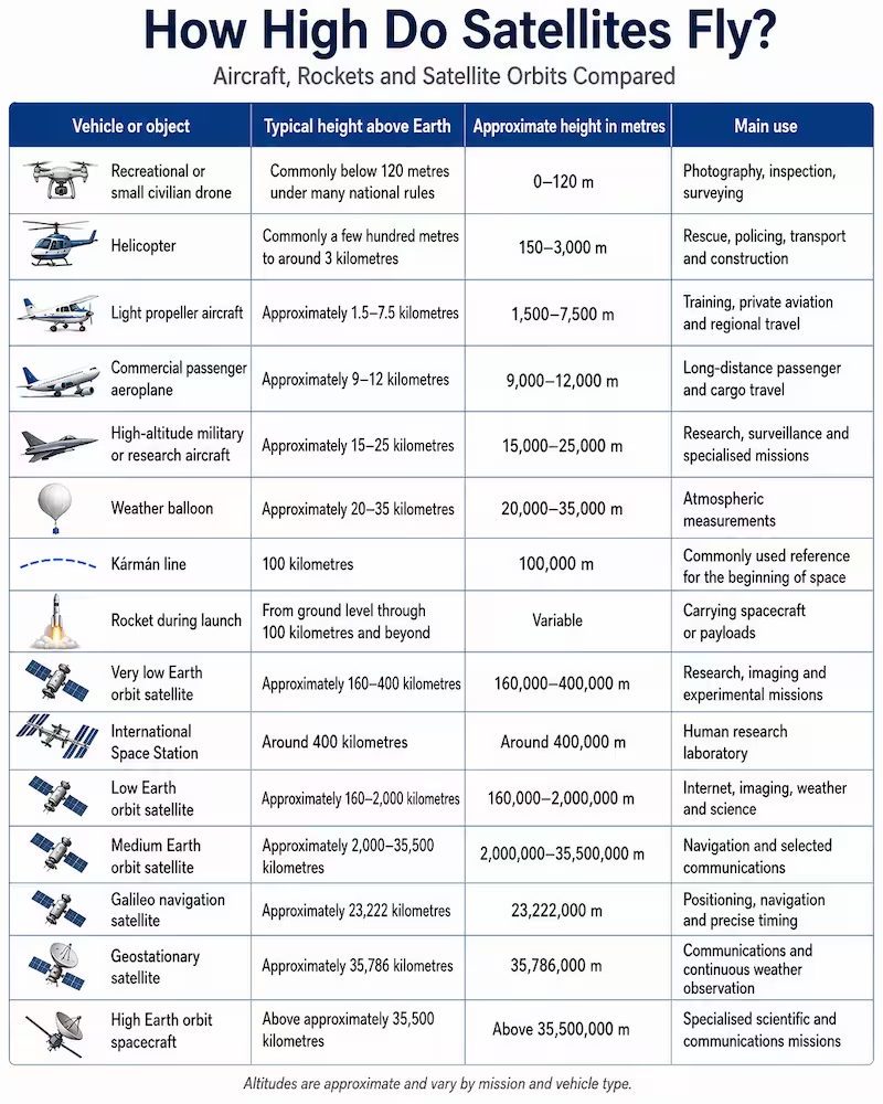
NASA Earthdata classifies low Earth orbit as approximately 160 to 2,000 kilometers above Earth, medium Earth orbit as approximately 2,000 to 35,500 kilometers and high Earth orbit as the region above that.
How high does a helicopter normally fly?
There is no single standard altitude for every helicopter.
Helicopters can fly very close to the ground during take-off, landing, rescue work, firefighting and construction. During normal travel they may operate from several hundred meters to a few kilometers above sea level, depending on terrain and airspace requirements.
Some specialized helicopters can reach much greater heights, but their performance reduces as air becomes thinner. Payload, temperature, wind, rotor design and engine power all affect how high a helicopter can operate safely.
Unlike an aeroplane, a helicopter can hover and take off vertically, making it useful where runways are unavailable.
How high does a passenger aeroplane fly?
Commercial passenger jets generally cruise at around 9,000 to 12,000 meters, equivalent to approximately 30,000 to 40,000 feet.
At those heights:
- the air is thinner;
- aerodynamic drag can be lower;
- fuel efficiency can improve;
- aircraft can travel above much ordinary weather;
- passenger cabins must be pressurized.
Aircraft do not operate in outer space. Their wings and engines depend on the atmosphere.
Even a passenger aircraft at 12 kilometers remains far below the commonly used 100-kilometre boundary of space.
Where does space begin?
There is no physical line painted across the atmosphere.
The atmosphere gradually becomes thinner with increasing altitude. One widely used reference is the Kármán line, positioned 100 kilometers above sea level.
It is often used to distinguish conventional atmospheric flight from spaceflight.
However, legal and scientific definitions can vary. The important point for readers is that ordinary aircraft remain far below this region.
A passenger aircraft flying at 10 kilometers has reached only around one-tenth of the Kármán-line altitude.
How high does a rocket fly?
A rocket does not have one fixed flying height.
An aeroplane may climb to a cruise altitude and then remain close to that level. A rocket continuously changes altitude and speed as it passes through the atmosphere and enters space.
Depending on the mission, a rocket may:
- cross 100 kilometers;
- deploy a spacecraft into low Earth orbit;
- carry a navigation satellite towards medium Earth orbit;
- place a communications satellite into a transfer orbit;
- send a probe towards the Moon;
- escape Earth orbit entirely.
The rocket is primarily a transportation system. It provides the energy and speed required to deliver a satellite or spacecraft to the correct path.
Why does a satellite not simply fall back to Earth?
Satellites are affected by Earth’s gravity and are continually falling towards the planet.
However, they are also moving sideways at very high speed. Earth’s curved surface falls away beneath them at approximately the same rate.
The result is orbit: the spacecraft repeatedly falls around Earth rather than directly into it.
Reaching a high altitude is therefore not enough. A launch vehicle must also give the satellite the correct horizontal speed and direction.
If the spacecraft travels too slowly, it will descend. If it travels too fast, it may enter a different orbit or escape Earth’s gravity.
What is low Earth orbit?
Low Earth orbit, or LEO, generally extends from approximately 160 to 2,000 kilometers above Earth.
This region contains most active satellites.
LEO is widely used for:
- broadband internet;
- Earth imaging;
- environmental monitoring;
- human spaceflight;
- scientific missions;
- weather observation;
- military reconnaissance;
- technology demonstrations.
Many low Earth orbit spacecraft circle Earth in roughly 90 to 130 minutes, depending on their exact altitude.
Advantages of low Earth orbit
Satellites in LEO are relatively close to Earth, which can provide:
- stronger imaging detail;
- lower communications delay;
- reduced launch-energy requirements;
- easier re-entry at the end of a mission;
- frequent observation of different locations.
Disadvantages of low Earth orbit
A single LEO satellite cannot continuously cover a large part of Earth.
Global communication systems may therefore require hundreds or thousands of satellites moving in coordinated constellations.
Satellites in lower orbits also experience more atmospheric drag and may require regular orbital adjustments.
What is medium Earth orbit?
Medium Earth orbit, or MEO, lies between low and high Earth orbit.
It is particularly important for global navigation satellite systems.
Europe’s Galileo satellites operate at approximately 23,222 kilometers above Earth. NASA Earthdata identifies Galileo as an example of a medium Earth orbit constellation.
Other navigation systems include:
- the United States’ GPS;
- China’s BeiDou;
- Russia’s GLONASS;
- Europe’s Galileo.
India’s NavIC and Japan’s QZSS use combinations of regional and higher-orbit architectures.
Navigation satellites transmit extremely accurate timing signals. A receiver compares signals from several spacecraft to calculate its position.
What is geostationary orbit?
A geostationary satellite orbits approximately 35,786 kilometers above Earth’s equator.
At this altitude, its orbital period matches Earth’s rotation. When positioned in a circular orbit directly above the equator, the satellite appears to remain above approximately the same part of Earth.
NASA notes that this provides almost continuous observation of one geographical region.
Geostationary orbit is valuable for:
- television broadcasting;
- telecommunications;
- weather monitoring;
- emergency communications;
- large-area data relay;
- selected military communications.
Advantages of geostationary orbit
A ground antenna can remain pointed towards approximately the same location in the sky.
One spacecraft can also cover a very large geographical area.
Disadvantages of geostationary orbit
The great distance creates a longer communications delay than low Earth orbit.
Geostationary satellites can also have more difficulty serving extreme northern and southern latitudes because they remain above the equator.
A simple height comparison
A passenger aeroplane at 10 kilometres may appear high, but it remains extremely close to Earth compared with orbital spacecraft.
| Comparison | Approximate height |
| Passenger aeroplane | 10 km |
| Beginning-of-space reference | 100 km |
| International Space Station | 400 km |
| Typical low Earth orbit constellation | 500-1,200 km |
| Navigation satellite | 20,000-23,000 km |
| Geostationary communications satellite | 35,786 km |
The International Space Station is approximately 40 times higher than a passenger aircraft cruising at 10 kilometers.
A geostationary satellite is more than 3,500 times higher than the same aircraft.
What are satellites used for?
Satellites support far more than television signals and photographs of Earth.
They form part of the infrastructure behind transport, finance, agriculture, telecommunications, security and disaster response.
Communications and internet access
Communications satellites transmit information between widely separated locations.
They support:
- broadband internet;
- satellite television;
- telephone services;
- airline communications;
- maritime communications;
- emergency networks;
- military communications;
- connections to isolated islands and rural communities.
Low Earth orbit systems can provide lower delay because they operate closer to Earth. Geostationary spacecraft can cover much larger areas with fewer satellites.
Navigation and precise timing
Satellite navigation is used by smartphones, aircraft, ships, emergency services, farmers, surveyors, construction companies and transport fleets.
Less visibly, satellite timing signals help synchronize:
- banking transactions;
- stock-market systems;
- telecommunications networks;
- electricity grids;
- computer networks;
- transport infrastructure.
The strategic importance of navigation systems is one reason major powers have developed their own constellations rather than relying completely on another country’s service.
Weather forecasting
Weather satellites observe clouds, storms, ocean temperatures, atmospheric moisture, wildfire smoke and volcanic ash.
Geostationary satellites continuously observe broad regions, while polar-orbiting satellites collect detailed global measurements as Earth turns beneath their paths.
NOAA states that low Earth orbit weather satellites provide a major share of the observations used by numerical weather-prediction models.
Modern geostationary satellites can also detect storm development, lightning, fires and changing atmospheric conditions with increasing frequency and detail.
Agriculture and food production
Satellite imagery helps farmers and governments monitor:
- crop condition;
- soil moisture;
- irrigation;
- drought;
- vegetation health;
- flood damage;
- changing land use.
Navigation signals are also used by automated and precision-farming machinery.
This can help reduce unnecessary use of fuel, fertilizer, water and pesticides.
Disaster response
Satellites can observe areas where roads, telecommunications and electricity networks have been damaged.
They may help emergency authorities identify:
- flooded communities;
- wildfire boundaries;
- damaged bridges;
- landslides;
- blocked roads;
- isolated populations;
- changes to coastlines;
- suitable routes for rescue teams.
NOAA describes satellites as supporting disaster preparation, response and recovery by giving emergency managers a wider view of affected areas.
Environmental and climate monitoring
Satellite observations allow scientists to study:
- forests;
- glaciers;
- sea ice;
- ocean levels;
- air pollution;
- greenhouse gases;
- changing coastlines;
- water quality;
- urban growth.
Because satellites repeatedly observe large areas, they can show changes that may be difficult to detect from ground measurements alone.
Maritime monitoring
Satellites support ocean-weather forecasting, navigation, communications and vessel monitoring.
Radar satellites are especially valuable because they can collect information at night and through clouds.
They can assist with:
- illegal fishing investigations;
- oil-spill monitoring;
- search and rescue;
- shipping-route planning;
- maritime-border awareness;
- detection of suspicious vessels.
Defense and national security
Military and dual-use satellites may support:
- reconnaissance;
- secure communications;
- missile-warning systems;
- navigation;
- maritime surveillance;
- border monitoring;
- weather forecasting;
- targeting and battlefield coordination.
Many civilian systems also have military applications. A navigation or weather satellite can serve commercial users while simultaneously supporting national defense.
Scientific research
Scientific satellites study Earth, the Sun, planets, stars, galaxies, radiation and the wider universe.Space observatories can detect forms of radiation that are blocked or distorted by Earth’s atmosphere.
Other scientific satellites measure gravity, ocean conditions, atmospheric chemistry and changes in Earth’s magnetic environment.
Search and rescue
Emergency beacons carried by ships, aircraft and people in remote locations can transmit distress signals through satellite networks.These signals help rescue authorities determine the approximate location of an emergency, even when conventional mobile coverage is unavailable.
What advantages do countries gain from owning satellites?
Operating satellites can provide economic, strategic and technological benefits.
However, simply registering a spacecraft does not automatically create major national power. The value depends on the satellite’s capability and whether the country can control, protect and use its data.
Greater national independence
A country with its own satellite capability is less dependent on foreign governments or commercial providers for critical services.
This can matter during:
- armed conflict;
- political disputes;
- sanctions;
- major disasters;
- international network failures;
- interruptions to foreign commercial services.
Independent systems can reduce the risk that essential information will be restricted or withdrawn.
Better national security
Countries can use their own satellites to monitor borders, maritime areas, military movement, infrastructure and potential threats.
Owning the complete system can also improve control over sensitive information.
A government relying entirely on foreign imagery may not receive it quickly enough or may face restrictions on how it can be used.
Control of communications
National or regional satellite systems can support government communications, emergency services and remote communities.
They can also provide backup when terrestrial networks are damaged by earthquakes, cyclones, floods or cyber incidents.
Economic growth
Satellite data can create commercial opportunities in:
- agriculture;
- construction;
- insurance;
- mining;
- transport;
- telecommunications;
- mapping;
- defense;
- weather services;
- environmental consulting.
A domestic space industry can also create skilled employment in engineering, software, data analytics, cybersecurity and advanced manufacturing.
Improved disaster preparedness
Countries exposed to cyclones, floods, fires, drought or earthquakes can use satellite observations to improve early warning and emergency planning.
The advantage may come from owning a satellite, participating in an international programme or purchasing guaranteed access to commercial data.
Monitoring natural resources
Earth-observation satellites can help governments monitor forests, water, minerals, agriculture, fisheries and coastlines.
This information may improve policy decisions and help identify illegal activity.
Diplomatic influence
A country can increase its regional influence by providing satellite communications, navigation support, weather information or disaster imagery to partner countries.
Satellite cooperation can become part of wider diplomatic, trade and security relationships.
Technology development
Building a satellite programme can develop expertise in:
- electronics;
- telecommunications;
- robotics;
- materials science;
- software;
- data processing;
- artificial intelligence;
- precision manufacturing.
The knowledge developed for space missions can also be applied to industries outside the space sector.
Revenue and commercial services
Satellite operators can earn revenue by selling:
- communications capacity;
- imagery;
- broadband;
- navigation support;
- weather information;
- data analytics;
- monitoring services.
However, satellites are expensive to design, launch, insure and operate. A national programme must have a clear long-term purpose rather than treating satellite ownership mainly as a symbol of prestige.
Owning satellites is only one part of space capability
The number of satellites associated with a country can be misleading.
A complete national space capability may include:
| Capability | Why it matters |
| Satellite manufacturing | Allows a country to design and replace spacecraft |
| Independent launch | Reduces reliance on foreign launch providers |
| Mission control | Allows direct operation and monitoring |
| Ground stations | Receive data and communicate with satellites |
| Navigation capability | Supports independent positioning and timing |
| Protected communications | Improves resilience and national security |
| Earth-observation analysis | Converts imagery into useful decisions |
| Space surveillance | Identifies risks and close approaches |
| Cybersecurity | Protects spacecraft and ground systems |
| Skilled workforce | Sustains the programme over many years |
The greatest strategic value comes from controlling the entire chain—from design and launch to data reception, analysis and operational use.
Does a country need to own satellites to benefit from them?
No.
A country can gain access through:
- international partnerships;
- commercial contracts;
- shared regional systems;
- open government data;
- hosted payloads;
- university missions;
- agreements with larger space powers.
New Zealand, for example, benefits from satellite weather information, communications, Earth observation, navigation and maritime services without operating one of the world’s largest national constellations.
Countries should assess what they actually need before committing to the cost of building and maintaining a large fleet.
Frequently Asked Questions
How much higher is a satellite than an aeroplane?
A passenger aeroplane commonly flies around 10 kilometers above Earth. The International Space Station is around 400 kilometers high, while a geostationary satellite is approximately 35,786 kilometers above the equator.
Do satellites fly like aeroplanes?
No. Aeroplanes generate lift while travelling through the atmosphere. Satellites remain in orbit because their forward motion and Earth’s gravity create a continuous path around the planet.
Can an aeroplane reach space?
Ordinary passenger and conventional military aircraft cannot reach orbit. Some specialized rocket-powered or spaceplane vehicles can briefly cross the boundary of space, but reaching orbit requires far greater speed.
Is the International Space Station a satellite?
Yes. A satellite is any object orbiting another body. The International Space Station is a large artificial satellite occupied by astronauts.
Why are internet satellites placed in low Earth orbit?
Their lower altitude can reduce communication delay and improve signal performance. The disadvantage is that many satellites are needed to provide continuous coverage.
Why are television satellites placed so far away?
Many television satellites use geostationary orbit. From Earth they appear to stay in the same part of the sky, allowing receiving dishes to remain pointed in one direction.
Why are navigation satellites higher than internet satellites?
A higher orbit allows each navigation spacecraft to cover a larger part of Earth and follow a stable, predictable path. Receivers use signals from several satellites to determine position and time.
Can satellites see through clouds?
Ordinary optical cameras cannot always see through thick clouds. Radar satellites can collect data through cloud cover and at night.
Can satellites see individual people?
Some commercial and government satellites can capture highly detailed imagery, but public claims about reading faces or continuously watching individuals are often exaggerated. Image quality depends on resolution, weather, viewing angle, timing and sensor type.
What happens when a satellite stops working?
It may be moved into a disposal orbit, lowered so it eventually re-enters the atmosphere or left in orbit. The outcome depends on its altitude, remaining fuel, design and applicable rules.
Do satellites stay in space forever?
No. Low-altitude spacecraft may eventually re-enter because of atmospheric drag. Objects in higher orbits can remain for decades, centuries or longer unless actively moved.
Can satellites fall on populated areas?
Most material burns up during atmospheric re-entry. Some larger or heat-resistant components can survive, although the probability of any one person being struck is extremely low.
Which satellite system is most important to daily life?
There is no single answer. Navigation and timing systems are essential to transport, banking, telecommunications and power networks, while weather and communications satellites provide equally critical public services.
Satellites operate across an enormous range of heights, from a few hundred kilometers above Earth to almost 36,000 kilometers and beyond.
Their altitude is selected according to the mission. Low Earth orbit is valuable for imaging and low-delay communications. Medium Earth orbit supports major navigation systems. Geostationary orbit provides continuous coverage of large geographical regions.
For countries, the advantage of satellites is not simply having objects in the sky. The greater value comes from reliable communications, independent information, disaster awareness, economic services and the ability to convert satellite data into useful decisions.
As satellites become more important to daily life, understanding where they operate and what they do is becoming part of understanding the infrastructure of the modern world.
Editorial Note: This article is intended for informational and educational purposes only. It provides analytical insights based on publicly available information and does not constitute financial, legal, or political advice. Readers are encouraged to consult official sources and expert advisors for verified guidance.
Information for Readers
This article is intended for general educational and informational purposes only. It does not promote any country, government, company, political position or strategic viewpoint. The content has been prepared using publicly available information from official organizations, space agencies and satellite databases.
Satellite numbers, classifications, ownership details and operational information can change frequently. Readers are encouraged to review the linked official sources and databases for the latest information and independent verification. Any reference to a country, company or organization is included for factual context and should not be interpreted as endorsement, criticism or political influence.
Who Controls the Satellites Orbiting Earth? Countries, Companies and Global Rules Explained